
India will need around 10 lakh additional skilled geospatial professionals, over and above its current workforce, to achieve the goals of the National Geospatial Policy 2022.
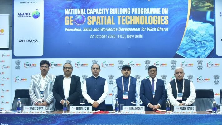
Addressing FICCI’s National Capacity Building Programme on Geospatial Technologies: Education, Skills & Workforce Development for Viksit Bharat, on Oct 22 in New Delhi, Mr Nitin Joshi, Additional Surveyor General, Northern Zone, Survey of India, said that skilled mid-level and senior professionals are especially scarce. “The policy has opened the door and technology will provide the tools, but it is skilled manpower that has to walk through these doors to build a Viksit Bharat.”
He proposed a formal certification system for surveyors, similar to those for lawyers and doctors. He also invited industry and academia to partner with Survey of India’s National Institute for Geoinformatics Science and Technology, Hyderabad, through scheduled courses, custom-designed programmes and institutional partnerships.
On occasion, Dr Manoranjan Mohanty, Scientist ‘G’ and Head, National Geospatial Programme, DST, said DST has trained more than 6,000 professionals over the past decade through its multi-tier national capacity building programme. DST is working with AICTE and UGC on courses and certification, and geospatial technology is now a GATE subject. He called on industry to work more closely with academia by sharing real-world problem statements, offering internships and recruiting from campuses, and working with state governments. Dr Mohanty released the White Paper on India’s Geospatial Capacity Building Strategy : Vision 2030 and Beyond.
Dr V K Dadhwal, Visiting Professor, NIAS, said India has a five-to-eight-year window, not until 2047, to build the workforce Viksit Bharat requires. He identified fsour gaps to close: aligning academic training with current industry tools, turning policy into usable foundational data, moving solutions from pilot to implementation, and building talent at scale across disciplines.
Mr Rajesh Mathur, Senior Advisor, ESRI, said geospatial technology has moved from survey and mapping to a powerful decision-support system and a mainstream IT component. Future professionals will need programming, enterprise integration and domain skills alongside core GIS expertise, he said, which calls for close collaboration among industry, academia and user agencies.